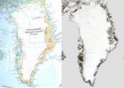
 Glaciologists and climatologists are racing to correct an error in the latest edition of The Times Comprehensive Atlas of the World, which they say overstates the extent of ice loss in Greenland over the past 12 years.
The 13th edition of the atlas was released on 15 September. The map’s publisher, London-based HarperCollins, said in a press release that it had “had to erase 15% of Greenland’s once permanent ice cover” since the previous edition in 1999. But researchers, who contend that the number is not backed up by scientific evidence, are worried that the error will undermine their credibility.
…the rest of this story, which appeared Tuesday, is available free at Nature News: [html] or [pdf]. Since then things have inched forward a bit on both sides so I’m including an update below:
First, Collins Geo, the imprint of HarperCollins which is responsible for the atlas, took down the original statement which I quoted in my story and replaced it with one my subeditor called “grovelly.” Basically, in its second statement the publisher admitted that the 15% figure didn’t belong in the press material and that it should have consulted scientists.
But the bigger problem was that it still didn’t explain how the publisher made the mistake, which scientists speculate consisted of publishing an outdated map of the extent of ice 500 metres thick or thicker in Greenland. Nor did they say then what they would do about it.
Researchers from the Scott Polar Research Institute (SPRI) called them out on that in a second statement of their own, here: http://www.spri.cam.ac.uk/media/pressreleases/timesatlas.html
Collins Geo posted a third statement on Thursday the 22nd in which they claimed they would release an updated map insert and cooperate with scientists in the revision. I’m quoting it in full because I don’t know whether they’ll simply take it down and replace it with another, as they did the first two located at this URL: http://www.timesatlas.com/News/Pages/Home.aspx?BlogID=61:
Since the publication of the Times Comprehensive Atlas 13th edition on 15th September 2011, controversy has raged about the depiction of Greenland in the Atlas. The editorial team at Collins Geo have apologised for an incorrect claim in the media material accompanying the launch. Now there has been further debate about the depiction of the ice itself.
On reflection and in discussion with the scientific community, the current map does not make the explanation of this topic as clear as it should be. We are now urgently reviewing the depiction of ice in the Atlas against all the current research and data available, and will work with the scientific community to produce a map of Greenland which reflects all the latest data. We will then create an insert for the current atlas showing this map and also give an explanation of the situation and how we have mapped it. Any material generated as a result of this activity will also be made available online and incorporated into the Atlas.
The one thing that is very apparent is that there is no clarity in the scientific and cartographic community on this issue but we have been consulting widely over the last week with experts in the field and have received a good response and support with new sources and data.
This most up-to-date information from all the latest sources would be a positive outcome. If the controversy about the Times Atlas encourages scientists to come together and clarify some of the confusion about our climate and how it is changing, the outcome will help the general public, and indeed all of us, better understand this complex issue.
While it’s nice to know they claim they’ll do something about the erroneous map, it still doesn’t explain how they ended up publishing it in the first place. It also implies more confusion than I found among researchers by stating that “there is no clarity in the scientific and cartographic community on this issue.”
I asked Collins Geo, who sent me that statement, to provide me with names of scientists who thought the situation was unclear or who would contradict the SPRI statement. I also asked them to identify the cartographers who worked on the map in the first place so that I might contact them and ask them how they made it. If I hear back, I’ll update this post.
In the meantime, I’ll add another description of CollinsGeo’s response to this error to my subeditors’: “weaselly.”
Re-draw the map to show climate change? Greenland ice mass maps causing political uproar . Greenland is losing some ice mass due to melting. The Times Atlas, however, is at the middle of a debate after publishing a map that revealed a 15 percent decrease in icemass. Environmental change due to global warming brings big changes.