Just how hot was that salsa? A European Space Agency (ESA) aircraft embarked on a mission on Sunday, 8 September, to answer this very question. The agency’s observational airplane—taking off from Easter Island, Chile—was geared up to collect data on a 24-year-old Earth observation satellite called Salsa as it burned up during atmospheric re-entry. The researchers wanted to know if Salsa would disintegrate completely or if it would instead take a long, slow tumble through the thickening air, with still unburnt pieces surviving the re-entry to splash into the ocean or make landfall somewhere.
As of press time, the team is still analyzing its images and streams of instrument output from Sunday’s re-entry. But they do at least report success in gathering the data. “With the knowledge gained, ESA’s Space Debris team hope to improve current prediction models,” a Monday blog post from the researchers stated, “As well as learn more about how a satellite burns up.”
Engineers today need to understand the surface of the moon in a way that they haven’t since the Apollo era. This year, amidst a flurry of commercial, American, Indian, Japanese, and other recent missions, the agency plans to expand a tool originally designed as a one-stop shop for satellite missions observing the Earth to cover our celestial neighbor.
Around 2016, NASA’s technology-transfer program began working on a centralized index of Earth Observation (EO) remote-sensing datasets, computer models, and software. This was motivated by a desire to avoid the all-too-possible scenario of a poor young NASA intern being tasked with creating new software to process satellite imagery and then discovering only at the end of the project that another arm of the sprawling space agency had already done the work.
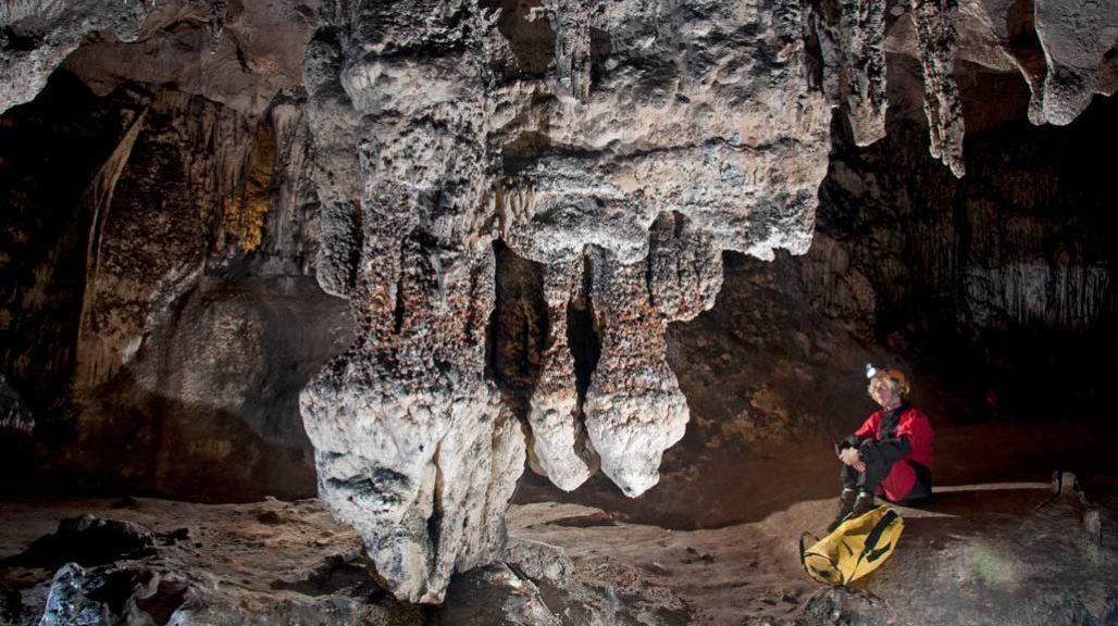
The future of sea level rise may be written into the walls of coastal Spanish caves.
Mineral “bathtub rings” deposited inside the limestone Artà Caves on the Balearic island of Mallorca show how high seas rose during the Pliocene Epoch — a time when Earth was about as warm as it’s expected to get by 2100. Those mineral deposits suggest the planet’s seas were around 16 meters higher on average than they are today, researchers report August 30 in Nature.
For several days in late September 2015, heavy rains soaked the earth surrounding the district of El Cambray II in Guatemala. On the first night of the following month, steep slopes, long held in place by thick, tropical tree roots, suddenly gave way, burying hundreds of homes in mud up to 15 meters deep. At least 280 people died.
Officials had warned residents for years that the area was at risk, but a mixture of poverty and mistrust leads some of the poorest people in Central America and beyond to build and live on marginal land. Still, residents of El Cambray II might have been willing to temporarily evacuate, if they had received a credible and precise warning. And if such warnings were available worldwide, they could help reduce the 3,000 deaths attributed to landslides every year. Continue reading Soil in the Forecast→
Technology policy editor at IEEE Spectrum Magazine